A walk in Oakland’s original platform

29 April 2024

I was asked to lead a walk in the old part of Oakland for a group of engineering geologists that ends at a brewpub. The 3.8-mile route I chose feels too good to keep private. It’s as much about interesting parts of town as about interesting bits of geology.

Here’s how it relates to the geologic map.

Start down by Heinold’s near the wolf, in Jack London Square.

Admire the fountain, check the nearby bathroom, then head along the shore, past the pavement, to the point where Lake Merritt Channel reaches the Estuary. Admire the hills running from here to Mission Peak, down the waterway in Fremont. This is the shape of the East Bay: a row of high hills, a level plain, a wide bay.

The channel, once upon a time, separated the villages of Oakland and San Antonio (later named Brooklyn). Boats were the usual way between the towns — Oakland the squatter village of farm estates wrangling with Don Vicente Peralta over ownership of his ranch land, San Antonio the older shipping depot for Don Antonio Peralta’s ranch and the farms of his peaceable neighbors.

Turn hillward and take Oak Street, then Fallon Street to the Oakland Museum of California. The whole walk so far, the last mile and a half, skirts the edge of the natural platform that made Oakland such an attractive site for developers. The sunken museum entrance on 10th Street is right on the line between this platform, made of windblown sand dunes that accumulated during the latest ice age, and old wetlands that have been filled in since 1850. The dunefield slopes up to the left and the filled land still lies low.


View down 10th Street past the museum on the left

Enter the museum and walk through to the public garden, a good place to sit or use the museum’s bathrooms. Along the way, say hi to J. B. Blunk’s redwood sculpture “The Planet.”

In the garden, notice how the museum works with the natural slope.

Exit the far side and cross the busy 12th Street causeway to Lake Merritt. Here’s where to study the hills and perceive the level landforms around the lake that formed at different times in the latest ice age. (I’ve made an annotated panorama of just this view.) After that, walk up onto the dune platform, by crossing the lawn next to the Camron-Stanford House, and go left a block to 13th Street. From there to City Hall is about a mile passing by some major buildings old and new.

At City Hall, inspect the moat around the building, which is part of its base-isolation retrofit after the 1989 earthquake. This landmark piece of seismic engineering is in all the textbooks. (A similar system was recorded in action during the recent Taiwan earthquake; the video is on Xitter.)

The last mile winds through picturesque parts of old Oakland. One notable building is the Wilcox Block on Broadway at 9th Street, our oldest commercial structure. It survived the great earthquake of 1868, the year it was built, without significant damage, as well as 1906 and 1989.

The route ends in the middle of a tempting set of brewpubs that have made the old Warehouse District a beer fan’s destination. Which to choose is an exercise left for the reader.

Further earthquake reading: Philip Fradkin

15 April 2024

Lately I’ve been going through my bookshelf and revisiting some memorable titles by and about geology, from the 1830s to today. Today I want to share three standout books of particular relevance to Oakland readers, all by the late Philip L. Fradkin (1935-2012). They constitute his “earthquake trilogy,” published between 1998 and 2005. They all concern our particular place between the Pacific and North America plates. They’ve stuck in my mind for decades and still inform my approach in this blog.

Fradkin offered this explanation of the trilogy on his former website:

As a journalist and resident of California since 1960, I am quite familiar with disasters, having observed all types and having been a victim of fires and floods. I wrote in The Seven States of California that there were three ways to deal with such disasters: leave the state, take up religion, or live one day at a time, the last being my personal preference.

So I set out to explore the splitting of the earth’s crust, my designated batter for exploring the effect of nature on humans, first in a general overview and California-centered book, Magnitude 8, then in a wilderness setting, Wildest Alaska, and finally in an urban setting, The Great Earthquake and Firestorms of 1906. In this manner my Earthquake Trilogy unfolded.

As he hints, his treatment goes beyond mere earthquakes to explore the ways we carry on our lives on a planet capable of dealing us death and wholesale destruction. What follows is based on reviews I wrote long ago somewhere else. Both the books (all still in print) and the reviews have held up well.


Palm oases mark the San Andreas fault trace near Indio.

Magnitude 8: Earthquakes and Life along the San Andreas Fault sets the gold standard for treatments of California’s seismic side: the geology, geography, history and political significance of our earthquakes. Fradkin presents not just the familiar cautionary facts and arguments, but also the peculiar sardonic attraction of California’s all-but-official state hazard and the effect of earthquakes on its landscape and inhabitants. He visits the fault’s full length, from Shelter Cove to Bombay Beach and beyond. Like me, he’s more curious about the fault than fearful of it, while aware of its constant threat. He was the same kind of day-at-a-time Californian as me, although I unlike him would not build my house practically upon it.

My review


Phil Stoffer stands by the creeping San Andreas fault near San Juan Bautista.

Wildest Alaska: Journeys of Great Peril in Lituya Bay explores the relations between landscape and culture in America’s most dangerous locality. Fradkin called this his most personal book. Lituya Bay is a rugged fjord in remote southeastern Alaska crossed by the Fairweather fault, whose frequent earthquakes launch huge masses of glacier ice and rockslides into the water causing colossal tsunamis. The bay’s entrance on the stormy Gulf of Alaska, barred by a glacial moraine, is navigable for only minutes at slack water in good weather. Nature looms there, and the human presence is precarious. Even the book’s geologists feel the chill along the spine, and the ghosts of the bay, witnesses to repeated catastrophe since ancient times, reach surprisingly far into our world. Fradkin went there “to explore the dread,” my phrase in Deep Oakland. I too have visited Lituya Bay, and our cold Pacific fog reminds me, like him, of that perilous place. The great natural forces so heightened there are great here, too. Our local libraries do not have this title, but it’s precious to me.

My review


In 1906 the San Andreas fault ruptured here, near Fort Ross.

The Great Earthquake and Firestorms of 1906: How San Francisco Nearly Destroyed Itself is a sweeping, definitive survey of the iconic American urban disaster that delves into how the city’s movers and shakers responded. As Fradkin’s publisher put it, “after the shaking stopped, humans, not the forces of nature, nearly destroyed San Francisco in a remarkable display of simple ineptitude and power politics.” The aftermath is the subject that scares me the most when I think about the Hayward fault, and there are important lessons for Oaklanders at all levels of citizenship. Both in 1906 and after hurricane Katrina in 2005, the bedrock of human nature fractured in very similar ways. What happened there will happen here some day. Fradkin’s journalistic presentation of original material brings the great quake to life from beyond the veil. He has the best stories, including many no one else has found. The Internet Archive maintains a copy.

My review

A theme that crosses all three books, one I barely touch on in my own Deep Oakland, is that while we can venture into wild nature expecting its dangers and tasting its corresponding thrills, wild nature is just as capable of visiting its dangers on us at home. Earth and civilization are not separate things, and both are prone to break along known fractures. These are books to study when you’re ready for the next level.

Remillard Park, Berkeley

1 April 2024

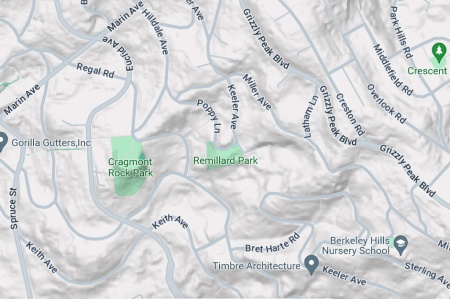
Remillard Park is one of Berkeley’s “rock parks,” but it’s very different from its fellow rock parks, some of which I’ve written about (like here and here). People have urged me to check it out — not that I need urging — and last week I found the time to give it a close look.

The park preserves an old landmark of the Berkeley hills called Pinnacle Rock. It sits uphill from Cragmont Rock, which is typical Northbrae Rhyolite like the stuff in the other rock parks.
We’re lucky that in 1861, the eminent photographer Carleton Watkins was hired to record landmarks in what remained of the San Antonio Rancho under the ownership of Vicente and Domingo Peralta. He printed two photos of Pinnacle Rock, one that’s been featured in books and newspaper articles and a second one I’m identifying here for the first time.


Pinnacle Rock from the south, not, as some assert, from Cragmont Rock.


Pinnacle Rock from the west. Images courtesy Bancroft Library, cleaned up a bit by me.

Around the turn of the century, the land in the Berkeley hills was purchased, subdivided and developed as particularly elegant streetcar suburbs: Cragmont, Northbrae, Thousand Oaks and so on. Peter Remillard, the wealthy brickmaker and prodigious landowner who got his start in Oakland, acquired the Pinnacle Rock property, but any plans he had for an estate there died with him in 1904. The land stayed in the family, and in 1963 his daughter Lillian, better known as the fabulous socialite Countess Dandini, gave it to the city of Berkeley for a park on the condition it bear the family’s name.

More about the rock later; that’s the top part of the park. The bottom part of the park is interesting too.

The south and southeast side of Remillard Park is an undeveloped stretch where Keeler Avenue abruptly gives way to Keeler Path, which crosses a scooped-out slope to intersect Sterling Avenue, where Keeler Avenue resumes. But the land is subdivided into housing lots and a standard right-of-way.

This is a big, persistent landslide scar, the uppermost part of the notorious Keith Slide, Berkeley’s largest active landslide. The vacant plots are telltale evidence as well as the land itself. The newspapers have reported houses around here that were damaged and destroyed by mudslides, from the 1940s to the 1990s, but none at this exact location. Keeler Avenue was platted in the 1900s decade and is shown as continuous in street maps dated through 1949, but the gap appears in the 1973 map. My guess is that houses were never built here, because the papers would otherwise have reported their destruction.

Keeler Avenue’s name honors the remarkable Charles Keeler, whose book The Simple Home was the guidestar for the local Arts & Crafts movement. Among his other precepts based on “conjuring the beauties of nature into being at [one’s] very doorstep,” Keeler praised the narrow, winding lanes that make the hill neighborhoods both so charming and so dangerous during fires or earthquakes. I think it’s fitting that nature, in the form of a creeping landslide, imposed itself in turn on a neighborhood he conjured into being.

In Remillard Park, the land has the classic scooped-out shape, steep headscarps and groundwater leakage of a slump. This photo shows the biggest scoop behind a drainage feature, one of at least two built to control the slump.

The flat floor is soaked right now and nurturing wetland vegetation. Little streams are trickling into it. Check it out, but careful where you step.

Pinnacle Rock is still imposing, mostly untouched except by vegetation that has crept in since the Ohlones were prevented from their practice of regular burning.

Even in the old photos, the rock appears quite different from those lower on the slopes. Unlike the smooth faces and rounded surfaces of the Leona Rhyolite outcrops, Pinnacle Rock is rugged and rough at all scales from eyeball to fingertip.

I climbed the rock, which is feasible, with care, even for a guy in his seventies, and the view from the top rewarded the effort.


Cragmont Rock in the middle distance.

Some people say this rock consists of the Leona volcanics, which has a similar reddish color and crops out nearby, but up close it’s quite different. The color, when it can be discerned under a carpet of lichens, is not a surface stain but integral, and the rock is shot with disorganized veins of hydrothermal quartz.

Moreover, the rock responds to hydrochloric acid on every surface, a sign that it’s impregnated with calcite and probably other carbonates. Its ragged, almost fractal surface indicates that rain and weather are successfully attacking it. Pockmarks all over its upper surface contain loose particles of the red-brown matrix set free by dissolution, and small annual plants seem to like them.

To end the suspense, I’ll say that this is considered to be the elusive “silica-carbonate rock” I’ve been seeking for a few years now. This material, also known as listwanite, results when hot carbonate-rich fluids invade serpentine rock and transform its minerals. It’s associated with mercury and gold mineralization, although not consistently.

At this point I would usually insert part of the geologic map of this area, but I don’t fully trust it. Suffice it to say that Pinnacle Rock is mapped within a belt of serpentinite, which I can’t yet confirm but would make sense. Most of the great landslides of the Berkeley and El Cerrito hills originate in serpentinite. I did find one boulder that might preserve a thin remnant of the original serpentine.

In addition to these observations, I noted two different sets of faults. The more prominent set is oriented due north-south and displays nice slickensides.

They’re especially plain along the base of the west side, facing the picnic tables. These appear to be “dry” without associated mineral veins. The lesser set is orthogonal to them and associated with calcite veins, the whitish crusts in this photo.

I can’t yet speculate which set is older. But the first set is roughly parallel to the nearby Hayward fault, and they probably were active when this chunk of the Earth’s crust was being hauled north during the past few million years.

It’s easy to picture that when volcanism was emplacing the Northbrae Rhyolite, farther downhill, it also punched a pulse of chemically active fluid up through the serpentine that created a chimney of listwanite, which has been gradually emerging via erosion ever since.

The pinnacle is fragile, penetrated by cracks at all scales. Its tumbledown structure lends itself to rock climbers, and Berkeley’s climbing pioneers practiced their rope-based techniques on Pinnacle Rock starting a century ago, leaving many bolts and pitons that still see use. Bouldering routes on the rock are marked with climbers’ chalk.

On the downhill side of Pinnacle Rock, the small pinnacle shown in the 1860s photo is still there.

Many chunks seem to have fallen off the main rock since then, most likely in the 1868 earthquake and possibly in 1906 too. If an earthquake strikes while you’re standing here, look sharp and step away!